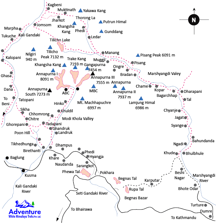
The Annapurna Circuit Trek map is the first thing I looked at when planning my recent adventure. If you’re thinking about trekking in Nepal, understanding the route is very important. The Annapurna Circuit is famous for its amazing landscapes, cultural diversity, and the challenge it offers. We followed the map closely during our trek, and I want to share what I learned to help you prepare for this incredible journey.
Starting Point: Besisahar
Most trekkers start the Annapurna Circuit from Besisahar, a small town that lies about 6-7 hours’ drive from Pokhara. On the map, you’ll see that Besisahar is the gateway to the mountains, and the trail follows the Marsyangdi River. The first few days are filled with walking through green forests and traditional villages. We enjoyed this gentle start, which gave us time to get used to walking every day.
Following the Marsyangdi River
One of the main features on the Annapurna Circuit Trek map is the Marsyangdi River. The trail runs alongside it for many days. This part is filled with beautiful waterfalls, suspension bridges, and local settlements. We passed through places like Bhulbhule, Jagat, and Dharapani, all marked clearly on the map. Each village has guesthouses where we rested and enjoyed local food.
Crossing the Thorong La Pass
The most famous part of the trek is crossing the Thorong La Pass, which is also clearly shown on the map. The pass sits at 5,416 meters and is the highest point of the trek. The climb to Thorong La is steep and challenging, but the views from the top made it all worth it. We started early to avoid the cold and finished the climb just before noon. On the map, you’ll see that after the pass, the trail heads down towards Muktinath, a sacred place for both Hindus and Buddhists.
Descending Towards Jomsom and Beyond
After crossing the pass, the map shows a gradual descent through dry, rocky landscapes. We enjoyed the change from green forests to wide-open spaces. The trail leads to Jomsom, a popular town with an airport and many guesthouses. From here, many trekkers either fly back to Pokhara or continue to explore nearby areas. We took a short break in Jomsom before finishing our trek.
Using the Annapurna Circuit Trek Map on the Trail
Carrying a physical or digital map was very helpful. While the trail is mostly well-marked, there are some places where it can be confusing. We used the map to check distances, elevation changes, and nearby villages. It helped us plan our daily hikes and decide where to rest.
Why a Map Is Important for This Trek
The Annapurna Circuit covers a large area with many different terrains. Without a map, it’s easy to miss important details like the best routes or alternate paths. We found the map helped us understand how the trek would unfold day by day and prepared us mentally for the challenges ahead.
Final Thoughts
The Annapurna Circuit Trek map is more than just a guide—it’s your companion on the journey. It shows the path through beautiful landscapes, mountain passes, and traditional villages. For us, having a clear map made the trek smoother and more enjoyable. If you plan to take this route, I recommend studying the map well, packing it with you, and using it to make your trip safe and exciting.